 (42)")
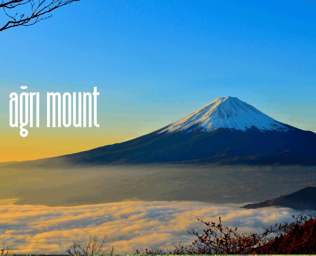
1. Mount Ararat (Ağrı Dağı) – 5,137 m
Mount Ararat, rising to 5,137 meters, is the highest mountain in Turkey and an emblematic peak of Eurasia. Situated in the Eastern Anatolia Region near the borders with Armenia and Iran, Ararat is a dormant stratovolcano with a permanent snowcap and extensive glaciers. The mountain holds immense cultural and religious importance due to its association with the story of Noah’s Ark, which is believed to have come to rest on its slopes after the Great Flood. For Armenians, it remains a national symbol, while for Christians and Muslims alike it represents a sacred site.
Geographically, Mount Ararat consists of two cones: Greater Ararat (5,137 m) and Lesser Ararat (3,896 m). Its glaciers feed rivers that flow into the Aras Basin, while the mountain’s slopes feature alpine meadows and endemic flora. Wildlife includes wild goats, foxes, wolves, and migratory birds. Access to the mountain is typically through Doğubeyazıt in Ağrı Province or Iğdır. Climbers must obtain permits due to the region’s strategic border location. The standard climbing route involves multiple camps, usually at 3,200 m and 4,200 m, before summiting. The best season is July–September.
Ararat is not only a mountaineering challenge but also a cultural tourism destination. The nearby Ishak Pasha Palace, Kurdish cultural heritage, and local hospitality complement the natural grandeur of the peak. Today, Mount Ararat stands as a unique convergence of myth, history, and natural beauty.
2. Mount Cilo (Uludoruk) – 4,135 m
Mount Cilo, also known as Uludoruk, is the second-highest peak in Turkey at 4,135 meters. Located in the Hakkari Province of southeastern Turkey, it belongs to the Cilo–Sat Mountains, an extension of the Taurus Mountain range. The region is characterized by rugged peaks, deep valleys, and permanent snowfields, making it one of the most dramatic alpine landscapes in the country.
The mountain is geologically diverse, with limestone, schist, and volcanic formations shaping its jagged profile. It is home to Turkey’s largest non-volcanic glaciers, including the Cilo Glacier, which lies in its northern valleys. Flora and fauna include alpine grasses, rare orchids, wild sheep, wolves, and birds of prey.
Access to Mount Cilo is challenging due to its remote location and the region’s historical security restrictions. Van serves as the nearest major city, from which travelers proceed to Hakkari and further into the Sat Valley. Climbing routes are technical and require professional mountaineering experience. Activities such as trekking, camping, and ice climbing are popular among experienced adventurers.
Culturally, the area is rich with Kurdish traditions, and the villages surrounding Cilo maintain centuries-old lifestyles. Mount Cilo thus offers not only physical challenges but also a deep cultural and ecological immersion.
3. Mount Süphan – 4,058 m
Mount Süphan, at 4,058 meters, is the third-highest peak in Turkey and the second-highest volcano after Ararat. It rises majestically on the northern shore of Lake Van, within Bitlis Province. As a stratovolcano, its conical structure and summit crater lake make it an extraordinary geological feature.
The slopes of Süphan are covered in volcanic rock, steppe vegetation, and alpine meadows. During summer, wildflowers bloom, attracting photographers and botanists alike. The fauna includes foxes, wild goats, eagles, and various endemic species. Its proximity to Lake Van creates a unique microclimate, with panoramic views of the vast lake visible from its summit.
Access is possible from the towns of Ahlat, Adilcevaz, or Tatvan. The ascent is less technical than Ararat, making it more accessible for semi-experienced climbers. The standard route begins near Adilcevaz at about 2,000 meters and includes one or two camps before reaching the summit. Best climbing season is July to September, when snow is limited to the summit.
In addition to mountaineering, Süphan offers eco-tourism opportunities, including trekking, camping, birdwatching, and cultural tours around Lake Van, home to ancient Armenian churches and Kurdish villages. Mount Süphan combines geological wonder with cultural richness.
4. Mount Kaçkar – 3,937 m
Mount Kaçkar, the highest peak of the Kaçkar Range in northeastern Turkey, rises to 3,937 meters. Located in Rize Province, it is part of the Pontic Alps and represents the wild heart of the Black Sea mountains. The Kaçkars are famous for their lush greenery, deep valleys, alpine lakes, and glaciated peaks.
The region experiences heavy rainfall, resulting in dense forests at lower elevations and alpine meadows at higher altitudes. Endemic plant species, brown bears, chamois, and diverse birdlife inhabit the area. Geologically, the mountain is composed of granite and metamorphic rocks, with cirques and glacial valleys shaping its terrain.
Access is via Rize’s Çamlıhemşin district, with routes passing through picturesque highland villages such as Ayder. The standard climbing route is from the Yukarı Kavrun village (2,200 m). The climb involves traversing glacial valleys and rocky ridges, usually requiring two days. The best climbing season is July–August, though winter sports and even heli-skiing have become popular in recent decades.
Beyond climbing, the Kaçkar Mountains are a hub for cultural tourism, offering visitors the chance to experience traditional Laz and Hemşin cultures. Wooden highland houses, folk music, and local cuisine make the journey an unforgettable cultural experience alongside its natural beauty.
5. Mount Erciyes – 3,917 m
Mount Erciyes, at 3,917 meters, is a stratovolcano dominating the Central Anatolian city of Kayseri. It is the highest mountain of Central Anatolia and one of Turkey’s most significant winter sports destinations. Its symmetrical volcanic cone and snow-covered summit make it an iconic landmark of the region.
Geologically, Erciyes is a Quaternary stratovolcano composed of lava domes, pyroclastic flows, and basaltic formations. It last erupted thousands of years ago, but its volcanic legacy is visible in the surrounding landscape. The slopes host steppe vegetation, alpine flora, and in winter months, thick snow cover.
Access is extremely convenient, as Kayseri is a major city with an international airport. The Erciyes Ski Resort, located at around 2,200 meters, has developed into a world-class facility with dozens of ski lifts and slopes catering to all levels. In summer, the mountain offers trekking, mountain biking, and paragliding.
Historically, Erciyes has been a beacon for travelers since ancient times, appearing in Roman and Byzantine records. Today, it combines modern tourism infrastructure with natural allure. For climbers, the summit ascent is possible in both summer and winter, though technical ice equipment is required in snowy conditions. Mount Erciyes thus embodies the dual identity of being both a sports hub and a natural wonder.
6. Little Ararat (Küçük Ağrı Dağı) – 3,896 m
Little Ararat, standing at 3,896 meters, is the twin peak of Greater Ararat and lies directly to its southeast, near the Turkish–Iranian border. While considerably lower than its massive counterpart, Little Ararat is remarkable for its almost perfect conical shape. Unlike Greater Ararat, which is broad and glaciated, Little Ararat rises steeply and symmetrically, making it visually striking from a distance.
The mountain is volcanic in origin and largely barren, with sparse vegetation due to its altitude and semi-arid climate. The lower slopes host steppe plants and grazing pastures, but the upper regions are rocky and devoid of flora. Unlike Greater Ararat, there are no permanent glaciers, though snow can linger on the summit in colder months.
Access to Little Ararat is generally through the same towns as Greater Ararat, such as Doğubeyazıt or Iğdır. However, climbing routes are shorter but steeper. Climbers typically ascend from the Eli village area, and while the mountain is technically less demanding than its larger sibling, its steep gradient requires physical endurance.
Culturally, Little Ararat often appears in the shadow of Greater Ararat’s biblical fame, yet it contributes to the symbolic landscape of the region. The twin peaks together dominate Eastern Anatolia and remain a defining feature of the Armenian Highlands. For mountaineers seeking an alternative to the heavily regulated Greater Ararat, Little Ararat provides a challenging yet rewarding expedition.
7. Mount Demirkazık – 3,756 m
Mount Demirkazık, reaching 3,756 meters, is located in the Aladağlar National Park within Niğde Province. Known as the “iron stake” due to its sharp, rocky summit, Demirkazık is one of Turkey’s most iconic climbing destinations. It represents the heart of Turkish mountaineering culture and has become a training ground for generations of climbers.
The geology of Demirkazık is predominantly limestone, resulting in jagged ridges, steep cliffs, and vertical walls that attract technical climbers. The lower slopes feature alpine pastures and mountain streams, while the upper sections are rugged and rocky, with snow persisting well into late spring.
Access to Demirkazık is usually through Çukurbağ village, which serves as the base for expeditions. From here, climbers approach via Emli Valley or Cimbar Canyon, two of the most scenic and challenging approaches. Routes vary from trekking paths to technical rock climbing pitches, making the mountain suitable for both intermediate and advanced climbers.
Culturally, the Aladağlar region is renowned for its pastoral traditions, with local villagers practicing transhumance. This cultural layer, combined with breathtaking landscapes, enhances the experience for visitors. Today, Demirkazık stands as a symbol of adventure in Turkey, uniting nature, geology, and mountaineering spirit.
8. Mount Kızılkaya – 3,725 m
Mount Kızılkaya, at 3,725 meters, is the highest peak of the Aladağlar Range, which spans the provinces of Niğde, Kayseri, and Adana. Its name, meaning “Red Rock,” reflects the reddish limestone and granite that form its summit. Kızılkaya is less famous than Demirkazık but geologically and geographically more imposing.
The mountain’s terrain is rugged, with sharp ridges, scree slopes, and karst formations. Its high-altitude environment sustains alpine flora such as gentians and endemic steppe grasses. Fauna includes wild goats, foxes, and raptors. Snow covers the summit for much of the year.
Access is possible from both Niğde and Kayseri. The most common route is from the Emli or Sokullupınar valleys. Climbing Kızılkaya requires technical skills due to its steep rock faces and unstable scree fields. It is considered one of the more demanding summits in Turkey, attracting seasoned climbers seeking a challenge.
Beyond sport, Kızılkaya also serves as an ecological treasure. The Aladağlar National Park, which houses the peak, is known for its biodiversity, glacial valleys, and alpine lakes. For this reason, the mountain is significant not only for mountaineering but also for conservation and eco-tourism.
9. Mount Verçenik – 3,710 m
Mount Verçenik, the second-highest peak of the Kaçkar Range, rises to 3,710 meters in Rize Province. It is often overshadowed by Mount Kaçkar itself, but among climbers and nature enthusiasts, Verçenik is known for its wild beauty and demanding routes.
The mountain is composed of granite and metamorphic rock, with cirques, sharp ridges, and glacial lakes decorating its slopes. The Verçenik Plateau at its base is dotted with alpine meadows, where transhumant villagers bring their herds in summer. The area is also home to endemic flowers and animals such as brown bears, wild boars, and lynxes.
Access is typically from Çamlıhemşin, via Ayder Plateau, followed by jeep tracks leading to the highland pastures. The ascent is technically challenging, requiring navigation through scree and glacier remnants. Weather conditions can be unpredictable, with heavy fog and rainfall common due to the Black Sea climate.
For those who reach its summit, the panoramic view is unforgettable, spanning the entire Kaçkar Range and even glimpses of the Black Sea coast. Mount Verçenik thus embodies the raw and untamed character of the Pontic Alps, making it a jewel for adventurous climbers.
10. Mount Hasan – 3,268 m
Mount Hasan, located in Aksaray Province, is one of Central Anatolia’s most prominent volcanic peaks, standing at 3,268 meters. It is part of the Central Anatolian Volcanic Province, alongside Mount Erciyes and Mount Melendiz. Its broad, twin-peaked structure dominates the Konya Plain and serves as a geographical landmark.
Geologically, Hasan is a stratovolcano composed of andesite and basalt. Though dormant, it was active during the Holocene epoch. The slopes are characterized by steppe vegetation, juniper trees, and volcanic rock formations. In spring, wildflowers add color to the otherwise arid environment.
The mountain is accessible from Aksaray city, with routes starting near Helvadere village. The climb is non-technical but physically demanding, typically requiring 6–8 hours. From the summit, climbers enjoy sweeping views of Cappadocia’s volcanic landscape.
Culturally, Mount Hasan has been significant since antiquity. Hittite, Roman, and Seljuk civilizations all referenced the peak in inscriptions and local traditions. Today, it is a popular trekking destination for both locals and international visitors. Combining natural beauty, volcanic history, and cultural depth, Mount Hasan stands as a central feature of Anatolia’s landscape.
11. Mount Baran – 3,524 m
Mount Baran, with an elevation of 3,524 meters, is one of the prominent peaks in the rugged Hakkari Province of southeastern Turkey. Situated within the Cilo–Sat range, Baran Mountain is part of an area often described as the “Alps of the Middle East” due to its dramatic topography and glacial valleys. The mountain is relatively less known internationally, but among regional climbers and researchers, it is celebrated for its pristine environment and technical climbing routes.
Geologically, Baran is composed primarily of metamorphic rock, including schist and marble, which give its slopes a jagged and fractured appearance. Snow remains on the summit for much of the year, and the valleys hold remnants of small glaciers. Alpine meadows around the base support seasonal grazing, while wildlife includes ibex, wolves, and golden eagles.
Access to Mount Baran is challenging due to the remoteness of Hakkari. The nearest major settlement is Yüksekova, from which expeditions can be organized with local guides. Climbing routes are technical and steep, appealing mainly to experienced mountaineers. For trekkers, the surrounding valleys and plateaus offer opportunities for camping, cultural encounters with Kurdish villages, and exploration of untouched natural landscapes.
Mount Baran remains a symbol of the untamed wilderness of southeastern Turkey, embodying both the natural richness and cultural heritage of the region.
12. Mount Karcı – 2,771 m
Mount Karcı, at 2,771 meters, is located in Denizli Province, western Turkey. While not among the very highest peaks of the country, it is the tallest in its region and offers a commanding view over the Aegean hinterlands. For the people of Denizli, Karcı Mountain is both a cultural landmark and a popular natural retreat.
The mountain’s geology is dominated by limestone, producing karst landscapes with caves and underground water systems. Vegetation varies from pine and cedar forests at lower elevations to alpine meadows near the summit. The area is home to wild boars, foxes, and diverse bird species.
Access is easy, as the mountain lies very close to Denizli city center. Roads and trails lead up to high-altitude villages, from where trekking paths extend to the summit. The climb is considered moderate and accessible to hikers of varying skill levels.
Beyond its recreational value, Mount Karcı contributes to the local climate and water resources, feeding streams that support agriculture in the region. It also offers panoramic views of Pamukkale’s white travertine terraces, a UNESCO World Heritage Site, making it part of a broader eco-tourism circuit in Denizli.
13. Mount Dedegöl – 2,992 m
Mount Dedegöl, standing at 2,992 meters, is the highest mountain in Isparta Province and one of the most prominent peaks of southwestern Anatolia. Part of the Western Taurus Mountains, Dedegöl is renowned for its wilderness, extensive plateaus, and its role in local culture.
Geologically, the mountain is composed of limestone and dolomite, resulting in dramatic cliffs, caves, and karstic valleys. Snow remains on the summit well into spring. The flora includes cedar and juniper forests, while higher areas support endemic alpine plants. Wildlife includes ibex, lynx, and various raptors.
Access is typically through Eğirdir town, situated by Lake Eğirdir, a major hub for eco-tourism. The Melikler Plateau at the base of the mountain serves as a popular campsite, especially during the annual Dedegöl Mountaineering Festival, which attracts climbers and nature enthusiasts from across Turkey.
The summit climb is strenuous but non-technical, making it suitable for trekkers with good fitness. From the top, views extend over the Taurus range, Lake Beyşehir, and the fertile plains of Isparta. Dedegöl thus combines natural grandeur with cultural vibrancy, offering both adventure and relaxation.
14. Mount Karakaya – 3,534 m
Mount Karakaya, with an elevation of 3,534 meters, is situated in Van Province in eastern Turkey. Though less well-known than neighboring giants like Ararat and Süphan, Karakaya is a significant peak for regional climbers due to its steep slopes and relative isolation.
The mountain is formed primarily of volcanic rock, a legacy of the tectonic activity in the East Anatolian highlands. Its barren upper slopes contrast with the cultivated valleys below, where agriculture and animal husbandry dominate local livelihoods. Vegetation is sparse above 2,500 meters, while snow patches linger on the summit during much of the year.
Access is generally through Van city, followed by long drives into rural areas near Gürpınar. Climbing Karakaya requires endurance and route-finding skills, as there are no established facilities or marked trails. Its remoteness makes it appealing to adventurers seeking solitude.
Karakaya’s cultural context is also important. The mountain is surrounded by Kurdish villages, where traditional hospitality is extended to visitors. This combination of geographic isolation, physical challenge, and cultural richness makes Mount Karakaya an underrated but rewarding destination for mountaineers.
15. Mount Sandıras – 2,295 m
Mount Sandıras, rising to 2,295 meters, is located in Muğla Province, southwestern Turkey, near the popular tourist towns of Köyceğiz and Fethiye. Despite its relatively modest elevation compared to other Turkish peaks, Sandıras is renowned for its biodiversity, highland villages, and mythological associations.
Geologically, Sandıras is composed of limestone and schist, producing rugged cliffs and fertile valleys. Its slopes are covered with pine and cedar forests, while higher elevations host endemic plant species. The mountain is also home to rare wildlife, including the Sandıras frog, found only in this region.
Access is convenient, with roads reaching the highland settlements of Gökçeova and Çiçekli. From here, trekking routes lead through meadows, forests, and up to the summit. Activities include hiking, camping, and nature photography.
Culturally, Sandıras has been inhabited since ancient times, and local traditions remain strong in the villages. Highland festivals, folk music, and agricultural rituals are still celebrated. For eco-tourists and cultural travelers, Mount Sandıras represents the meeting point of natural beauty and Anatolian heritage.
16. Mount Ilgaz – 2,587 m
Mount Ilgaz, at 2,587 meters, is located on the border of Kastamonu and Çankırı provinces in northern Turkey. While not among the very highest peaks of Anatolia, Ilgaz is historically and culturally significant, as well as being one of the country’s most important winter tourism destinations.
Geologically, Ilgaz belongs to the Köroğlu Mountains, part of the North Anatolian range. Its slopes are covered with dense forests of pine, fir, and beech, creating a rich ecosystem that supports bears, wild boars, foxes, and many bird species. Snowfall is heavy during winter, creating an ideal environment for skiing.
The Ilgaz National Park encompasses much of the mountain, offering hiking trails, picnic areas, and camping sites. The Ilgaz Ski Resort, located at 1,850 meters, features ski lifts, hotels, and infrastructure, attracting thousands of domestic tourists every year.
Historically, Ilgaz has been referenced in Turkish poetry and folk songs, symbolizing natural beauty and romantic landscapes. Today, it stands as a hub where eco-tourism and winter sports merge, offering year-round recreational opportunities.
17. Mount Palandöken – 3,185 m
Mount Palandöken, rising to 3,185 meters, dominates the city of Erzurum in Eastern Anatolia. It is one of Turkey’s premier ski resorts and a center of winter tourism development. The mountain’s long slopes, reliable snow cover, and modern facilities have made it internationally recognized.
Geologically, Palandöken consists of volcanic and metamorphic formations. Vegetation is sparse at higher altitudes, but the lower slopes are covered with steppe grasses and shrubs. Snow cover typically lasts from November to May, making it one of the longest ski seasons in Turkey.
The Palandöken Ski Resort is located just 10 kilometers from Erzurum city center and only 15 minutes from the airport, giving it unmatched accessibility. The ski slopes stretch for more than 40 kilometers, with the longest run being 12 kilometers, among the longest in Europe.
Culturally, Erzurum is known for its Seljuk and Ottoman architecture, cuisine, and hospitality, which complement the mountain’s appeal. Palandöken represents Turkey’s ambitions to expand into global winter tourism markets, hosting events such as the Winter Universiade.
18. Mescit Mountains – 3,235 m
The Mescit Mountains, with their highest peak reaching 3,235 meters, are located between Erzurum and Bayburt. This range is less well-known than others in Turkey, but it offers unspoiled nature and significant biodiversity.
The geology of the Mescit Mountains is largely composed of volcanic and sedimentary rocks, creating rugged cliffs and high plateaus. The region experiences harsh winters with heavy snowfall, while summers are short and cool. Vegetation includes alpine pastures and forests of pine and oak at lower elevations. Wildlife such as wolves, bears, and eagles inhabit the area.
Access is through Erzurum or Bayburt, with small rural villages serving as starting points for treks. Mountaineering here is relatively unexplored, which appeals to adventurers seeking solitude. The lack of tourist infrastructure has preserved the authenticity of the region.
In addition to natural attractions, the Mescit Mountains host traditional highland festivals, where local communities gather during summer. This blend of cultural heritage and untouched alpine landscapes makes the Mescit range a hidden gem of Eastern Anatolia.
19. Mount Mercan – 3,362 m
Mount Mercan, at 3,362 meters, is located in Tunceli Province, within the Eastern Anatolia Region. It is part of the Munzur mountain system and lies within the boundaries of the Munzur Valley National Park, one of Turkey’s largest and most ecologically diverse protected areas.
The geology is dominated by limestone and metamorphic rocks, producing steep ridges and deep valleys. Glacial erosion has shaped cirques and small alpine lakes. Vegetation includes oak forests, alpine meadows, and endemic plant species. The fauna is particularly rich, with bears, lynxes, mountain goats, and numerous bird species.
Access is through Ovacık or Tunceli, with trekking routes leading into the national park. Climbing is moderately difficult, with routes requiring stamina but not necessarily technical skills. The views from the summit extend over the Munzur range and the rugged terrain of Dersim.
Culturally, the region is known for its Alevi heritage, traditional music, and spiritual practices, which add a unique dimension to eco-tourism. Mount Mercan thus represents both natural beauty and cultural depth.
20. Mount Munzur – 3,346 m
Mount Munzur, with an elevation of 3,346 meters, forms the backbone of the Munzur Mountains, stretching across Tunceli and Erzincan provinces. It is located within the Munzur Valley National Park, a UNESCO-recognized biosphere area noted for its rich biodiversity and cultural significance.
Geologically, the Munzur range is composed of limestone and dolomite, producing karstic landscapes with springs, caves, and waterfalls. Alpine meadows, oak forests, and endemic plants dominate its ecology. Wildlife includes bears, wolves, wild goats, and rare bird species such as the bearded vulture.
Access is from Erzincan or Tunceli, with trekking trails starting at villages like Ovacık. Mountaineering routes are not technical but require endurance. The best time to visit is July to September, when wildflowers bloom and weather conditions are stable.
Culturally, the Munzur Valley holds spiritual significance for the Alevi community, who regard its springs and landscapes as sacred. Annual festivals celebrate both the natural and cultural heritage of the region.
Mount Munzur epitomizes the harmony of nature and culture, offering a destination where eco-tourism, spirituality, and outdoor adventure converge.